
Port Erin Bathing Water Profile
 Current water quality classification is Excellent, based on weekly samples taken from 2019 to 2023.
Description
Port Erin beach is located on the south-west of the Isle of Man. The beach sits in a sheltered bay bordered by the tall cliffs of Bradda Head to the north. The beach is approximately 500 m long and consists of golden-white sand.
The Port Erin stream enters the bathing water with the main channel flowing across the main beach and into the sea. The surrounding land is urban and agricultural.
Port Erin beach is a good location for various sports such as kayaking and paddle boarding (equipment hire available), beach volleyball and football with nets installed during the bathing season. There are two swimming rafts installed during the bathing season which provide a marked route for open water swimmers.
The beach is also used for various events throughout the bathing season including live music, educational events hosted by charities and Port Erin festival of the beach and sea.
There is easy parking near to the beach including electric vehicle charging points. Public toilets, showers, cafes, shops, first aid and a defibrillator are all within walking distance of the bathing water.
For more information see the Visit Isle of Man website.
| Samples taken | Weekly throughout the bathing season |
|---|---|
| 2019 classification | ***Excellent |
| 2020 classification | ***Excellent |
| 2021 classification | ***Excellent |
| 2022 classification | **Good |
| 2023 classification | ***Excellent |
| Local authority | Port Erin Commissioners |
| Water sampling point | SC 194 689 |
| QR Code |  |
Water Quality Results
See the help page for additional information on interpreting these charts.
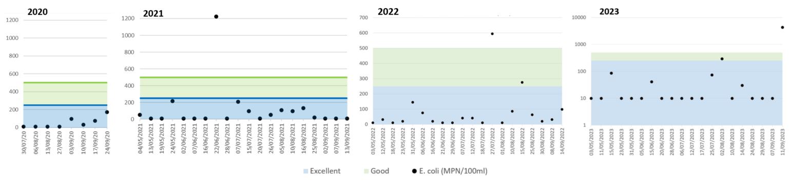
Escherichia coli (EC)
2024

2020 to 2023
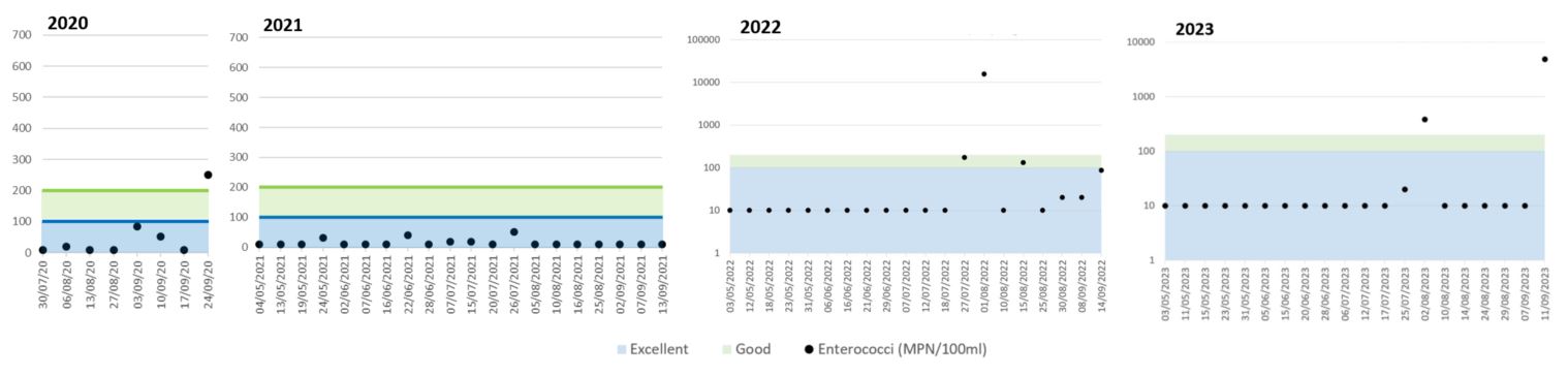
Intestinal Enterococci (IE)
2024
2020 to 2023
Catchment Description

The catchment surrounding Port Erin is approximately 1.43 km2. The Port Erin stream flows from farmland through the town to the beach. Surface water and highway drains discharge into the stream and directly into the sea.
Pollution Risk Forecasts
This bathing water can be subject to short term pollution. Short term pollution is caused when heavy rainfall or high tides wash faecal material into the sea from livestock, combined sewer overflows and urban drainage via rivers and streams. At this site the risk of encountering reduced water quality increases after rainfall and typically returns to normal after 1-3 days.
Investigations Statement
The Environmental Protection Unit is not currently investigating any pollution incidents within this catchment. To report any water pollution incidents; please call +44 1624 685885 or email environmentalprotection@gov.im
Pollution Management
It is the Environmental Protection Unit's role to drive improvement of water quality at bathing waters that are at risk of failing higher standards. It is natural for water to run off the land to the sea. Water quality at a bathing water is dependent upon the type and area of land (the catchment) draining to the water and the activities undertaken in that catchment.
Stream and Rivers

Streams and rivers are typically affected by human sewage, animal slurry and run off from roads.
The Port Erin stream which enters the sea is close to the bathing monitoring point. The Environmental Protection Unit monitor the Port Erin stream at Athol Park Glen twice a year to assess for chemical and nutrient concentrations.
The annual report on the routine water quality monitoring data is produced by the Environmental Protection unit.
Any reports of pollution will be investigated by officers and water samples collected if necessary.
Working with Manx Utilities

The urban area of Port Erin immediately behind the beach is served by surface water, foul water and combined sewer networks. These networks are maintained by Manx Utilities with the foul waste being transported to Meary Veg sewage treatment works via the IRIS network.
There is a combined sewer overflow from the Port Erin Promenade pumping station which is not likely to impact on the bathing water quality.
Working with Local Authorities
Surface water can flow into the Port Erin stream from outfalls and highway drains. This can affect water quality, particularly after periods of rainfall.
Heavy rain falling on pavements and roads often flows into surface water drains or highway drains, ending up in local rivers and ultimately the sea. The quality of bathing water may be adversely affected because of such events.
Working with the farming community
During and after periods of heavy rainfall, run off from agricultural areas is greatly increased, and the quality of the bathing water may be adversely affected. The Environment Protection Unit are working with farmers to encourage better farming practices and improve water quality in the surrounding areas.
